Product Name:
MyGeoid Map
Summary:
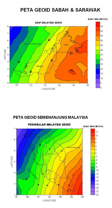
Malaysian Geoid Models, MyGEOID consists of two basic models namely WMGEOID04 in Peninsular Malaysia and EMGEOID05 in Sabah and Sarawak. MyGEOID could be supplied in L7030 or T738 topographic map size. These geoid models are hybrid of gravimetric geoids with GPS ellipsoid heights on leveled bench marks. Therefore, these values are suitable for use with GPS survey to obtain mean sea level directly without further transformation.
Description:
- MyGEOID can divide in to two::
- Separate Geoid Map in the size of Peninsular Malaysia, Sabah and Sarawak, Sabah or Sarawak.
- Geoid Map in the size of topograpgy map (30km X 30km) L7030 0r T736
Years of Observation:
2004/2005
Coverate:
Malaysia.
10 km dari garisan pesisir pantai Malaysia.
Price:
- Height of Geoid : MRY3.00 per point
- One map sheet 30kmx30km : MRY250.00 per sheet
- Peninsular Malaysia : MRY20,000.00 per set
- Sabah : MRY10,000.00 per set
- Sarawak : MRY10,000.00 per set
- Federal Territory of Labuan : MRY250.00 per set
Information Needed When Applying the Data
- For a single point:
- Station id/latitude/longitude/height (Ellipsoidal/MSL) – (degrees decimal)
- Station id/latitude/longitude/height (Ellipsoidal/MSL) – (degree, minutes, second)
- Station id / X / Y / Z (meter)
- Station id / N / E / Height (General UTM in meter)
*Kedua-dua maklumat tersebut diperolehi dari cerapan GNSS di lapangan.
- For one map sheet (30km x 30km):
- Center coordinates of selected area (WGS84)
How to purchase:
Bagi model-model MyGeoid sedia ada, ia boleh diperolehi secara atas talian melalui E-Biz JUPEM Geoportal manakala permohonan transformasi ketinggian menggunakan MyGeoid dan penyediaan lembar geoid pilihan, pemohon boleh menghubungi Seksyen Graviti dan Falak, Bahagian Ukur Geodetik, JUPEM.